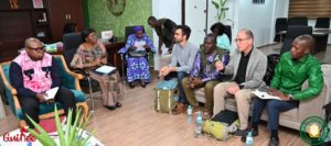
On the topic of political perspectives on reforestation, we present the arboRise project, the social, economic and environmental context and the governance issues facing such a project in the Global South. This is an opportunity for rich exchanges with the students, for example on gender issues or climate justice.
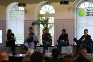
This year, we had the opportunity to take part in the discussion forum organised by the Berlin Global Village, with Michael Küppers-Adebisi (Officer for Diversity & Community Development), Christan Manahl (former EU ambassador to Africa) and Selina Diaby (SYSTEMwandel: Genug für alle! beim BundJugend), on the theme of decolonisation, moderated by Carlotta During from the European Academy Berlin.
Our thanks go to Arnaud Leconte, Director of CIFE and GEGPA, for this opportunity to share ideas. We wish the students every success in their future careers.
Collecting the seeds of our 40 local tree species is the very first step of a reforestation campaign. It’s the job of the representatives of the 250 “seed families”: in each village, the women involved in the arboRise project collect the seeds of their seed tree. Each woman has a tree of a different species, to ensure the best possible biodiversity.
Each harvester then brings her 20,000 seeds to the village centre, where they are counted and paid for. This is also an opportunity for our partner GUIDRE to assess the quality of the seeds delivered.
Then all the seeds from the different seed trees are mixed together and divided into piles, which are then put into bags and given to the “field families” who will be responsible for sowing the seeds.
Do the math: collecting the seeds means 5,000,000 seeds ! Spread over 500 hectares, that’s 10,000 seeds per hectare, or one seed per square metre.
The committee has implemented the transformation of the association arboRise into a foundation of public utility, following the decision of the General Assembly of 12 December 2022. The arboRise foundation pursues exactly the same goals as the association:
To fight global warming through reforestation [1] according to the United Nations Sustainable Development Goals 13 and 15.
To experiment with natural reforestation methods that enhance biodiversity and share the results of these experiments [2]
Involve local populations in reforestation and enhance their forest heritage [3]
To raise awareness among the populations of high-income countries of the usefulness of reforestation as a means to fight global warming[4]
The foundation does not pursue any economic goal and does not aim to make a profit.
The foundation’s reforestation campaigns are implemented in the countries located in the south of West Africa (notably Guinea, Ivory Coast, Ghana, Togo, Benin) with the aim of creating a corridor of fauna and flora linking, through agroforests, the natural parks of these countries. The initial region, from which the reforested strip will be progressively extended, is constituted by the sub-prefectures of Linko, Damaro and Konsankoro in the Prefecture of Kerouane in the Republic of Guinea.
[1] To maximize the reforested areas, the approach of the arboRise foundation is “low-tech” and “low-cost”.
[2] The intention of the arboRise foundation is that other reforestation actors can reduce their costs per hectare and maximize the reforested area.
[3] The biggest share of the revenue from carbon credits should benefit to local communities.
[4] Awareness-raising activities are subsidiary to the three previous goals and must not involve more than 5% of the foundation’s resources.
The tax authorities of the Canton of Vaud have validated the public utility of the arboRise foundation, which is thus exempt from corporate income tax. Donations to the foundation are tax exempt as well.
Being active abroad, the arboRise foundation is subject to the control of the Swiss Federal Supervisory Authority for Foundations. arboRise will in all likelihood have to deal with significant financial flows, so it is necessary to ensure that these resources are used wisely. The Federal Supervisory Authority for Foundations will check that its funds are used according to the statutory purposes (such a control would not have been mandatory for the association).
The arboRise foundation is now registered in the Commercial Register of the Canton of Vaud under the number CHE-210.113.196.
This legal framework provides increased security and stability for our partners and donors. This is essential, because in order to guarantee the sustainability of our reforestation activities, we are going to build lasting relationships with our future donors over several decades. We need stability to work in continuity.
The Counsil of the arboRise Foundation has a wide range of relevant skills to meet the statutory objectives:
Eric Bettens, Lausanne city councilor (les Vert.e.s) and member of the finance committee, will facilitate the work of the board as president of the foundation board
Mariame Camara, former vice-president of the association’s committee, originally from the Prefecture of Kérouané in Guinea, will bring her knowledge of Guinean society and the local context
Laurent Douek, former active member of the association’s committee, member of the board of the Swiss Philanthropy Foundation, will provide the board with his vast network and expertise in the field of foundation governance
Anne Giger Dray, specialist in sustainable management of renewable resources at the ETHZ, will provide the Board with insights from research projects (land use change, livelihoods, sustainability, governance and participatory management)
Alice de Benoît, city councilor of Lausanne (Green’liberals) and lawyer, will support the council in the legal field and promote transversal collaborations
John Pannell, Professor in Plant Evolution at UNIL, will contribute to the scientific robustness of the experiments conducted by arboRise.
The Foundation Board met on March 6, 2023 to define its operating mode.
As for Philippe Nicod, founder of arboRise, he will continue his benevolent commitment as director of the foundation until the foundation has sufficient resources to pay the person who will succeed him.
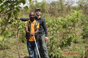
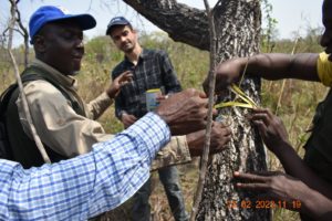
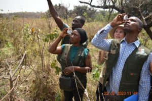
Our partner South Pole provided technical expertise in dendrometry training for the GUIDRE team:
Random selection of measurement sites
Establishment of 25m x 25m plots to measure tree biomass:
Measurement of tree diameter at breast height
Measurement of height with clinometers
Calculation of biomass based on wood density of each species
Adaptation of the plot size to the slope of the land
Establishment of 3m x 3m plots to count the existing biomass of the shrub vegetation
Establishment of 1m x 1m plots to account for the existing biomass of herbaceous vegetation
Three essential notions were addressed during these trainings:
Eligibility: a piece of land is only eligible for a carbon project when the forests have been cut down more than 10 years ago. A forest is an area of more than half a hectare with trees higher than 5 metres. Historical satellite images (Google Earth, Landsat, etc.) are used to verify eligibility. During our field visits we found that some areas that are deforested today appear as forest on some current satellite images, and vice versa. It is therefore important to choose the right satellite source and to learn how to interpret these images correctly, especially satellite images from 10 years ago. Our partner South Pole will carry out this analysis and then provide GUIDRE with eligibility maps. These will be used to immediately identify ineligible land (or land that will only be eligible in a few years’ time) when visiting landowners. When identifying new land, GUIDRE supervisors will also take care not to include parts of existing forests or armour-clad soils, on which vegetation is difficult to establish.
Baseline: The existing biomass on the land cannot be counted in the calculation of the carbon absorbed by the arboRise project (notion of additionality). This is why it is important to choose the fields with the least amount of trees, shrubs and grasses. It will also be necessary to classify the selected areas according to their vegetation cover in order to create statistical measurement strata. We will then proceed to measure the baseline, to calculate the volume of biomass to be subtracted from the project’s Emission Reductions.
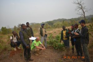
Ex ante measurements: scientific studies on forest biomass growth are numerous in Asia and South America, but rare in West Africa. This makes it very difficult to estimate the carbon sequestration potential of a project like arboRise. To compensate for this lack of scientific references, we will identify areas that were set aside by the authorities several years ago and on which the trees have grown. Measuring the current biomass on these plots will make it possible to deduce the average annual growth of the biomass and therefore the carbon sequestration potential of the project. Here on a plot of land set aside 23 years ago, near the village of Deyla:
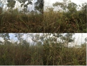
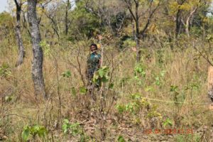
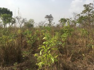
The three partners also visited 10 plots of land to be reforested in 2021 (for the record: 5,000 pellets of seed per hectare, sown without stacks). These visits led to the following observations:
The very strong natural regeneration complements the seedlings sown in 2021. The density of seedlings per hectare varies considerably depending on the nature of the soil and the fires. The three best sites have a density of 5000 stems per hectare, the three worst sites have a density of 500 stems per hectare.
Plants sown in 2021 and spared by the fires reach an average height of 1.7m
Out of 12 plots visited, only 3 were affected by the fires. The growth of the trees is slowed down by one year when a plot has been affected by fire. On the three affected plots, the plants are about 80cm tall.
The stakeholder consultation continued in Conakry from 27 February to 1 March. ArboRise, GUIDRE and South Pole project managers were able to exchange with the environmental consultancy Biotope Guinée, the IUCN representative for Guinea and the head of CECI.
The most important meeting took place with Mrs. Safiatou Diallo, Minister of Environment and Sustainable Development of the Republic of Guinea, and the members of her cabinet: Mr. Karim Kourouma, Secretary General, Mr. Aly Traoré, Head of Cabinet, and Mr. Jean-Louis Pelletier. Aly Traoré, Head of Cabinet, Ms. Oumou Doumbouya and Ms. Adama Diabaté, Heads of the Climate Risk Mitigation Department, Mr. Mohamed Fofana, National Director of Water and Forests and Mr. Pierre Lamah, Guinea’s Designated National Authority for the Green Climate Fund. The MEDD consultation was essential to strengthen collaborative links with the national authorities of the Transitional Government. It had been prepared in advance with all the services concerned, thanks to the organisation of Ms Adama Diabaté.
ArboRise would like to thank Her Excellency the Minister, and the members of her cabinet for the attention shown to the project and the repeated wish to intensify the collaboration. It is indeed one of arboRise’s statutory aims to share the lessons of its experiences and we will not fail to provide the Guinean authorities with the desired support. This will include, firstly, the contribution of the arboRise project to the Nationally Determined Contributions, in accordance with the Paris Agreements, secondly, the contribution of arboRise in terms of green jobs and reforested area, and finally, the training needed by the Directorate of Water and Forests to strengthen the impact of its reforestation programmes.
It is for this last purpose that the three partners finally met personally with Mr Pierre Lamah, in his capacity as Focal Point of the Green Climate Fund, to follow up on our request for financial support from the Green Fund.
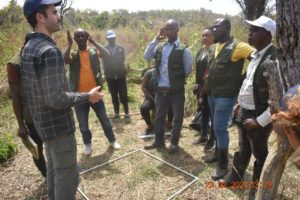
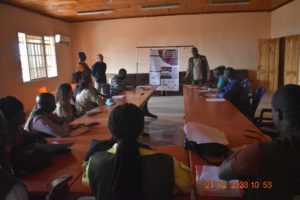
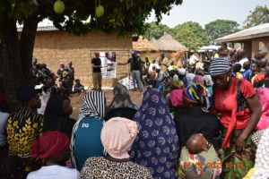
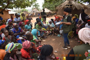
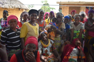
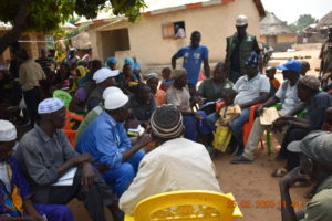
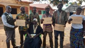
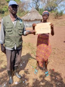
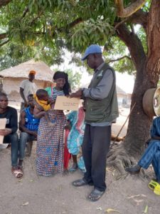
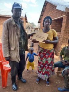
The Local Stakeholder Consultation (LSC) took place in the sub-prefecture of Linko from Tuesday 21 February to Saturday 4 March 2023.
Tuesday 21 February at the Prefecture of Kérouané, then with the sub-prefectural authorities in Linko:
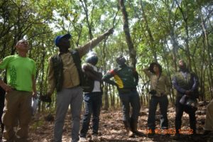
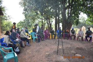
The 12-person team from the three partners, arboRise, GUIDRE and South Pole, then went to the villages of Linko, Forono, Booko, Diaradouni, Kissidou and Boidou. The8 local consultation consultation followed the same agenda each time:
Welcome by the village authorities, blessing of the meeting and documentation of the list of participants
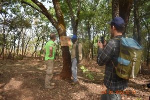
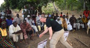
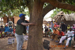
The presentation of the project, using two Posters, by Philippe Nicod (director of arboRise) with translation into the local language by Saidou Marega (executive director of GUIDRE). Small copies of the posters were placed in the immediate vicinity of the participants to facilitate reading.
Questions of understanding from the audience and spontaneous reactions
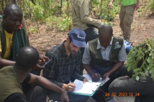
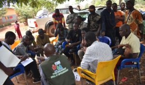
In-depth discussions, in local language, on the impacts and risks of the project in several focus groups. The women’s focus groups were facilitated by two GUIDRE staff.
Project appraisal forms and explanations of what will be done with the lessons learned from the Local Stakeholder Consultation
As can be seen from these images, participation was very strong and balanced in terms of gender, age group and level of involvement in the project. Many families expressed their desire to join the project and there were many touching expressions of appreciation.
After observing six meetings, the two groups of supervisors divided up the consultations in the remaining 20 villages, while the project management continued the LSC in Conakry.
For arboRise it is essential to understand the local impact of our reforestation activities. This is why we regularly carry out field surveys (example 1, example 2, example 3). As the Gold Standard carbon certification process shares this concern, we organised a very broad stakeholder consultation in February 2023. This consultation aims to
Inform about the details of the project and receive feedback from anyone potentially affected by the project
Exchange views and concerns in a free and transparent manner
Discuss the benefits, impacts and risks of the project
Establish a mechanism for ongoing communication and conflict resolution
Create the basis for close and sustainable collaboration
ArboRise and its partners South Pole and GUIDRE identified the following stakeholders:
The 250 seed families and 250 land families of the 26 villages participating in the first reforestation cycle
The authorities and the entire population of the 26 villages, and the members of the Community Management Committee created in each village
Prefectural authorities (Prefect, Secretary General, Prefectural Director of the Environment, Head of the Water and Forests section, Head of the OGUIB branch)
Sub-prefectural authorities (Sub-prefect, Mayor of the Linko Rural Commune, Vice-Mayors, Secretary General, District President, Imam of Linko, Sotikomo of Linko, Chief of the Linko Forestry Unit)
The national authorities of the Ministry of the Environment and Sustainable Development (Minister, Advisor in charge of sustainable development, Guinea National Designated Authority – Green Climate Fund, National Director of Water and Forests (DNEF), Head of Land Use Planning, DNEF)
To enable all interested people to participate, more than 700 personalised invitation letters were sent out 30 days before the start of the consultation, with essential logistical support from our partner GUIDRE. To include illiterate people as well, the invitation was broadcast on the local radio in Kérouané for five days in the morning and evening.
In order for each guest to be prepared, the invitation contained
a description of the project
the Sustainable Development Goals targeted by the project
SDG 4: Quality education
SDG 8: Decent work
SDG 13: Climate action
SDG 15: Life on earth (biodiversity)
all potential risks of the project according to the Gold Standard principles, as well as the measures planned to mitigate each specific risk:
Principle 1. Human rights
Principle 2. Equality between men and women
Principle 3. Health, safety and working conditions of the community
Principle 4.1 Cultural and historical heritage sites
Principle 4.2. Forced evictions and displacement
Principle 4.3 Land tenure and other rights
Principle 4.4 Indigenous Peoples
Principle 5. Corruption
Principle 6.1 Labour rights
Principle 6.2 Negative Economic Consequences
Principle 7.1 Emissions
Principle 7.2 Energy supply
Principle 8.1 Impact on natural water patterns/flows
Principle 8.2 Erosion and/or instability of water bodies
Principle 9.1 Landscape and Soil Modification
Principle 9.10 Areas of High Conservation Value and Critical Habitats
Principle 9.11 Endangered Species
Principle 9.2 Vulnerability to natural disasters
Principle 9.3 Genetic Resources
Principle 9.4 Discharge of Pollutants
Principle 9.5 Hazardous and Non-Hazardous Waste
Principle 9.6 Pesticides and fertilizers
Principle 9.7 Harvesting of forests
Principle 9.8 Food
Principle 9.9 Livestock
The correct receipt of invitations was confirmed by tallying:
ArboRise is proud to announce a strategic partnership with South Pole, a global leader in carbon reduction projects and strategies. South Pole develops and finances climate projects around the world (over 700 projects to date) to reduce carbon emissions, protect biodiversity and help the most vulnerable local communities adapt to climate change.
Under the Emission Reduction Partnership Agreement signed with South Pole, arboRise will benefit from
South Pole’s technical expertise to obtain carbon certification of our approach
South Pole’s resources to market the carbon credits generated by our reforestation campaigns
Pre-financing in the form of a loan to cover the costs of the planting phase
As a reminder, arboRise and the field-families make a mutual commitment over a 20-year period. Only the income from carbon credits will guarantee a fair remuneration for these families who commit their land to our project.
And only a carbon certification will guarantee to our donors
that the reforestation has actually been implemented (real)
that the reforestation would not have taken place without the project (additional)
that real biomass growth can be measured against a baseline, taking into account uncertainties and risks of leakage (e.g. if the project induces deforestation in other locations) (measurable)
that an external auditor from an accredited organisation has audited the project (verifiable)
that the sequestered carbon will be retained for 100 years (permanent)
That the sequestered carbon is only counted once (unique)
The agreement with South Pole is an essential step in making the project sustainable and ensuring its long-term economic viability.
A major step in the arboRise adventure was taken yesterday evening, 12 December, at the extraordinary general meeting of our association. following the committee’s proposal, the general assembly voted unanimously the dissolution of the association and transform it into an arboRise foundation.
Why ?
Reforestation is an activity that naturally takes time. Consequently, arboRise is committed to long-term partnerships:
In particular with the field families, the agreements extend over a period of 20 years. Following our on-site surveys, we are convinced that only the income from carbon credits will guarantee a fair remuneration for the Guinean families who commit their land to our project.
For our donors, only a carbon certification will guarantee them
that the reforestation has actually been implemented (real)
that the reforestation would not have taken place without the project (additional)
that real biomass growth can be measured against a baseline (initial measurement), taking into account uncertainties and risks of leakage (e.g. if the project induces deforestation in other locations) (measurable)
that an external auditor from an accredited organisation has audited the project (verifiable)
that the sequestered carbon will be retained for 100 years (permanent)
That the sequestered carbon is only counted once (unique)
The agreement with the company that will accompany us in the certification process will have a minimum duration of 10 years
How can we ensure the sustainability of our partnerships?
Stability is needed to work in continuity. Experience shows that associations are generally more fragile than other structures, such as foundations, whose statutes and governance are more stable. This is why the committee proposed yesterday to the extraordinary general assembly of 12 December 2022 to transform arboRise into a public utility foundation. This implies the dissolution of the association and the transfer of its assets to an arboRise Foundation, with the same statutory objectives as the association.
In all likelihood arboRise will have to manage large amounts of money, so it is necessary to ensure that these resources are used wisely. The Federal Supervisory Authority for Foundations will provide this security by checking that the funds are used in accordance with the statutory purposes. Such control is not mandatory for an association.
Finally, a foundation is a guarantee of seriousness that will facilitate fundraising.
The formal vote necessary for the dissolution of the association and its transformation into a foundation was submitted yesterday evening to the General Assembly, which unanimously approved the committee’s proposal by the 15 members present. The committee has been mandated to implement this transformation, planned for the beginning of 2023.
Our warmest thanks to all members for the trust you have placed in us and for your faithful support during these 27 months of associative life. Together we have achieved strong results. And this is only the beginning!
As it is extremely time-consuming to visit each of the 650 hectares restored by arboRise to assess the health of the new forests, we sought to measure tree growth remotely. But how to do this? NDVI sentinel 2 is the answer!
The European Union’s Sentinel II satellite takes an infrared photograph of the earth’s soil every 5 days with a resolution of 10m (1 pixel: 10m x 10m = 100m2). The data provide many indications about a region, such as humidity/aridity, the presence of fires, and also the nature of the vegetation. An important advantage is that the data is available free of charge (see Sentinel Playground).
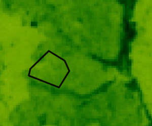
The value we are interested in is the “NDVI” (Normalized Difference Vegetation Index) which corresponds to the rate of vegetation cover on the ground, a good index of the quantity of biomass, therefore an index of the quantity of trees (forests appear clearly on the maps with a darker shade of green).
For each reforested area, the NDVI value (= shade of green) of each pixel is extracted and the median value, the biomass of the area, is calculated:
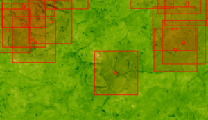
For each reforested plot, we then calculate the median NDVI value of the “background”, an area of 2km side around the plot (by subtracting the NDVI of the plots present in the background):
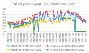
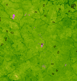
On the basis of the Sentinell II cloud cover index, we then eliminate all values with a probable cloud cover of more than 90% (the purple spots on the image below):
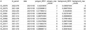
For each available day of data (75 per year) and for each plot, we obtain
The median NDVI of the plot
The cloud cover over the plot for that day
The median NDVI of the background
The background cloud cover for that day
…44815 lines for the period from January 1, 2021 to November 22, 2022…
The graph below represents the NDVI values for 2021 and 2022 over a year. The values of the days where the median background cloudiness on one or more fields was above 90% have been removed:
It can be seen that the NDVI in 2022 is lower than the NDVI 2021 (yellow and green lines below the red and blue lines). At this stage three hypotheses are possible:
It may be a change in the calibration of the satellite or the measurement (but this is unlikely) and this change should then apply uniformly to all 2022 measurements, but the NDVI of the Background decreases significantly more (-0.19) than the NDVI of the Polygons (-0.16)
2022 may have been drier than 2021, but this is not confirmed by the local population, who say that 2022 was rainier
There were more fires and deforestation in 2022…
The reason for this change needs to be investigated. For the time being, annual comparisons should be interpreted with caution.
On the other hand, the effect of the rainy season can be clearly seen:
A progressive increase in biomass from February to August
A significant cloud cover between June and October (less data for this period because of clouds)
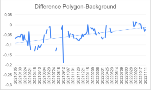
Great news: In 2021 the polygons (arboRise plots) have an average NDVI 5.2% lower than the background NDVI (normal, arboRise reforests bare land), but in 2022 the NDVI of the polygons is 3% higher than the background NDVI! And there is a positive growth in the difference between the biomass of the reforested plots and the biomass of the background, which means that the biomass on the arboRise plots is growing faster than in the surrounding area:
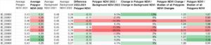
For the reforested areas in 2021, two years of data are available and can be compared: NDVI sentinel 2
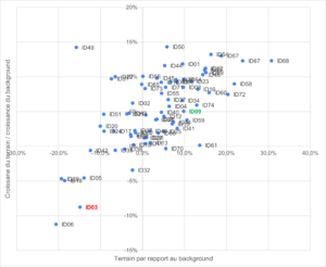
The visualization on this graph allows to identify the “good plots” (top right) from the “bad plots” (bottom left):
It can be seen that the majority of the plots are located in the upper right part of the graph, which is excellent news!
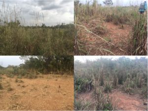
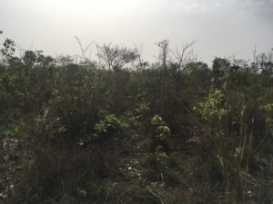
But how well does this satellite analysis match reality? We went to see on the spot what it was like for plots ID03 and ID09.
For the “bad” field n°3, we observe a depleted soil following several years of cultivation. Situated between two hills, it is probably an area where cattle used to transhumance towards a watering place (visible dung). The trampling makes it difficult for the vegetation to grow. However, small shrubs of 1.5m are visible and 4 remnants of trees are completely dry. No sign of fire. This low biomass in the field validates the satellite measurement of NDVI
As for plot 9, it is impossible to enter without a machete because the vegetation is so dense, especially the 3m high grasses. We can see several shrubs of about 2m and 3-4 trees of 8m. The land has obviously not been grazed or burnt. This higher biomass in the field validates the satellite NDVI measurement.
In conclusion, the field observations are consistent with the satellite measurements of biomass. It will of course be necessary to confirm this correlation with other examples.
With the help of these indices provided by the Sentinel II satellite, we will be able to target our visits to areas of high growth, to learn from them and to share these good practices with the owners of the land, whose satellite images indicate that they are less wooded. This will serve as case studies for the training of land families and Community Management Committees.
We also hope to inspire other reforestation projects to use this same technique to assess biomass growth on their plots and become more efficient.
A huge THANK YOU to Sergiy for his expertise in GIS and NDVI sentinel 2 data analysis and his valuable advice!


 …44815 lines for the period from January 1, 2021 to November 22, 2022…