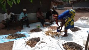
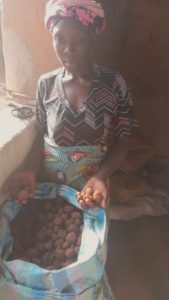
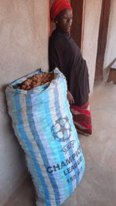
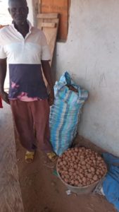
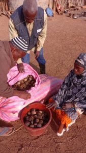
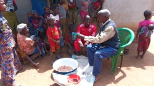
There are several steps to making a seeds bomb (or seedball). The first step is to mix the seed species in order to obtain a good specific diversity for each field:
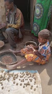
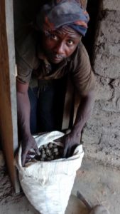
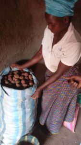
Then all the ingredients are brought together: clay from the lowlands, charcoal which must first be ground into dust, ash which will act as an insecticide and water to make a paste out of it all, which you then roll in your hand. In some families, everyone works at it: father, mother and children.
In this respect, yes, we too ask ourselves: is this child exploitation? Should we forbid these families to work together? Of course, the children have to go to school …but what happens if there is no school within 10 kilometres? There are many difficult questions that need to be answered with sensitivity.
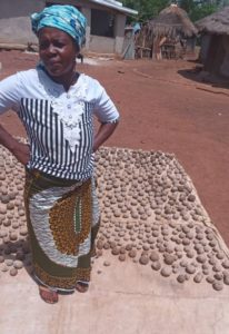
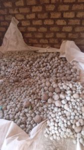
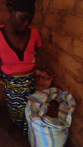
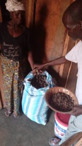
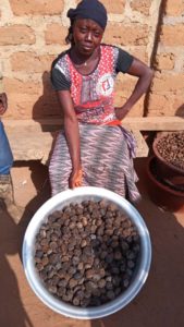
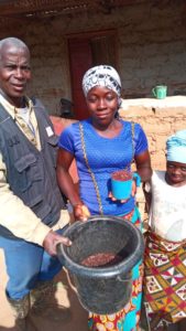
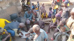
After the coating comes the drying stage, always impressive in the villages as our seeds bomb are found everywhere:
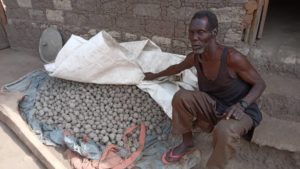
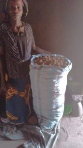
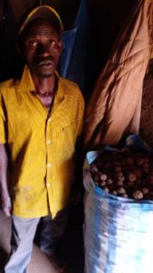
And finally, each family can proudly stand in front of its bag of 10,000 bombs of mixed seeds, ready to be scattered on the plots made available by the field families:
Sharing learnings is one of the statutory goals of arboRise. Why? We are convinced that by joining forces we altogether will have a greater impact. And if other organizations chose to adopt our low-tech and low-cost methods and manage to increase the area they reforest, it will be very beneficial for the climate.
It is also important to create policies that favor nature-based solutions and reforestation that takes into account the expectations of local populations. That’s why we spent two days in Berlin with the class of students of the Joint Master in Global Economic Governance and Public Affairs (GEGPA) of the International Center for European Training and the Luiss School of Government. Using the example of arboRise, we discussed the challenges of reforestation and the solutions available to governments to promote natural, participatory and sustainable solutions.
Because the idea was not only to transmit our knowledge but to benefit from the students’ knowledge too. Thanks to their passionate engagement, we were able to grasp some very good ideas that will help optimize our approach and make it even more sustainable. The sharing of learnings goes both ways!
The fight against climate change will have more impact if we join forces locally on the ground, with approaches like arboRise (empowering communities to implement best practices in reforestation, promoting biodiversity and improving living conditions) and globally by putting in place policies and governance that address ecological, social and economic challenges.
We have decided to extend the scope of our reforestation campaign to 500 hectares in view of the spectacular progress made by our team in the field over the last 2 months.
After convincing 180 families to join our project in January and February, i.e. 20 families more than expected, and as there were only 70 families left to convince in March and April, we quickly made the choice to gather 100 new families, i.e. 100 additional hectares. 100 hectares is a very important number of trees: about 50’000 new trees. From a financial point of view, this means increasing the annual budget by about CHF 20,000, which our resources easily allow.
These 500 hectares will be planted with 2’500’000 seed pellets from 250 different trees. A greater number of trees planted means a greater contribution to the fight against global warming, since a tropical forest of one hectare absorbs each year the equivalent of the CO2 emissions of a Swiss family.
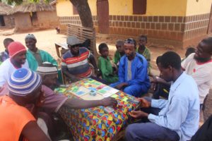
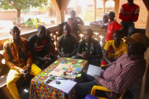
Do you remember the arboRise game ? On 8th February in Paris, we tested a playful approach to understanding decision-making processes in a village community. One month later, Léa Ackerer, commissioned by ETH’s ForDev, tests the game in the field, in the small village of Diaradouni and then in Manakoro, in the south of the Linko sub-prefecture.
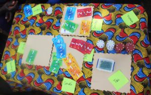
The arboRise game is very simple: the four players receive cards representing their fields, with different degrees of fertility. They can then play their cards (cultivate their fields) in several zones, representing the types of crops: food crops (cassava, fonio, etc.), cashew nut plantations for cash, or agroforests with arboRise. Each type of crop involves specific costs and income, as in real life. And as in real life, one can choose to spread out one’s activities or “bet” everything on a single crop.
What did this experience bring out? In addition to the smiles of the players, it seems that our game is a very good awareness-raising tool, to show the impact of the choice of crops (groundnuts, cassava, cashew nuts or reforestation by arboRise) on the prosperity of the community.
A key lesson seems to be ‘don’t put all your eggs in one basket‘: resist the lure of immediate gains and continue to grow food crops even if they are less profitable.
We also observed that women play more conservatively, while men take more risks. We had also expected more collective strategies to emerge, but the players chose to focus on their own interests. This is an important lesson: in our fieldwork we will make sure that we create the conditions to strengthen the cooperation between the families involved in our project.
Playing a role-playing game implies that a few simple rules are set and that it is then the players who invent new rules as the game progresses. Such an evolution implies that the game master invites the players to seize this space of freedom. This is of course what was done on the spot, but it is possible that our interpreter got caught up in the game and did not translate Lea’s instructions as faithfully as he should have. Such are the vagaries of fieldwork.
We will obviously continue to develop and use this game as a real awareness-raising tool. For more information on the use of serious games in development: https://www.commod.org/
Do you remember “anything is possible“? The new arboRise tree sowing adventure in Switzerland, by bringing together “seed families” and “land families”?
Well, preparations are well underway, with a first visit in situ and the choice of tree species to be sown. First of all, it is necessary to understand the nature of the land: type of soil, sunshine, altitude (and therefore average temperature), slope… What is the history of the plot, what could be its future?
After answering, even partially, these questions, comes the creative moment: what does the owner wish to see growing there? Tree sowing, yes, but what? stately trees or rather fruit trees? formal garden aligned with the line or rather English garden? forest garden, tasty forest? should there be a small path to reach the trees? and now which species of trees?
Then comes the distribution of species according to the location of the participants: “do you have chestnut trees in your region? will you be able to collect the seeds? The forests in Romandie are full of different species, let’s take use that!
Thanks to Catherine and Yannick for their generous welcome and to Rémy, Dany, Christine and Laurie for the enthusiasm and all the good ideas 😊 tree sowing with you will be gorgious!
Role playing games for arboRise? In the lively atmosphere of the Viaduc in Paris, a few budding apprentice farmers are learning (laughing) how to make the best crop choices. Should I plant groundnuts on my land or invest in a cashew plantation? Ouch, my fertile land should be left fallow! What should I do with the land planted with arboRise?
Experience in the field shows that a playful approach is often the best way to understand the decision-making processes within a group. And we have the ideal partner, as we have the expert advice of ETHZ researchers who are recognised specialists in the development of these games (as shown in this video). Role playing games allow each player to experiment with virtual choices, without having to face the consequences in real life. This space of freedom is conducive to the discovery of new forms of interaction between partners, both in and out of the game.
In a few rounds, the game developed by ETH for arboRise proved its relevance: it was very easy to simulate the possibilities offered by reforestation to the population and how they could adopt this new agroforestry culture. It was also possible to quickly see what risks the young forests planted by arboRise are running.
The next step is to play with the local population during the second field mission of our joint research project, in 10 days! In addition to understanding individual decision-making, the game will also highlight the processes of co-decision, mutual aid and self-management, which our action could encourage in the future.
ZeroCarb is the carbon coach for 120,000 SMEs in French-speaking Switzerland active in the service sector. The intelligent carbon footprint calculator. It is a tutorial that highlights the environmental actions that the SME has already implemented and suggests new measures to progressively reduce CO2 emissions to zero.
Why does arboRise support a carbon calculator for microenterprises? Many of our members and donors are climate conscious SME owners. In talking to these entrepreneurs we realised that they lack a tool to help them make the transition to a greener future. And it has to be affordable, because a small SME often does not have the resources to hire external consultants!
ZeroCarb provides a simple, fast and cheap solution to suggest relevant carbon footprint reduction measures to SME owners, and offers them an obvious solution to offset the remaining emissions: planting trees with arboRise!
Do you run a service sector company with less than 10 employees? ZeroCarb is for you! In less than 10 minutes you know the carbon footprint of your SME and get ideas on how to reduce it. Take advantage, the ZeroCarb carbon footprint calculator is still free!