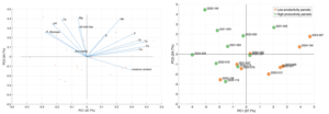
Camille Perrin and Alena Vasilyeva analysed soil samples taken from 19 sites: 10 sites where our trees are growing strongly according to our dendrometric measurements, and 9 sites where our trees are not growing well.
Alena and Camille show that two groups of factors explain our trees’ growth and that pH is a key determinant. The more acidic the soil, the less accessible the nutrients present in it are to plants (paradoxically, there is more phosphorus in the soil of the underperforming plots, as this phosphorus cannot be absorbed by the trees because it is more strongly bound to other atoms).
In temperate zones, liming is used to make the soil more alkaline, but lime is not readily available in our region. Ash can also be used (which is what farmers do when they burn trees to convert fallow land back into cultivated fields) or biochar (which we are going to try to introduce – we’ll talk more about that later!).
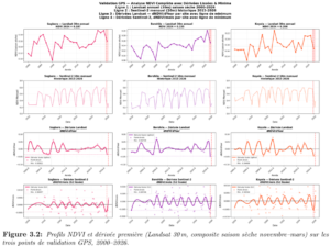
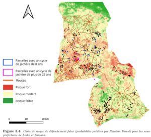
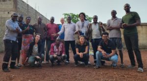
Predicting land clearing is important for our project. That is why, once again this year, we have collaborated with EPFL as part of a Design Project.
Feryel El Phil and Camille Dupré Tabti first demonstrated that the first derivative of NDVI values is a good method for identifying when land is being cleared.
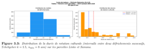
This enables them to calculate the crop rotation cycle for each plot of land. As can be seen below, this varies considerably: some plots have a rotation cycle of 7 years (roughly 2 years of cultivation, 5 years of fallow), whilst others can be as long as 25 years:
Building on these findings, they then produced a map showing the probability of land clearing in Linko and Samana and concluded that the risk of our plots being cleared increases if the land is easily accessible to farmers (close to the village) and if it is naturally fertile. We can therefore predict which land-owning families would be most likely to reconsider their participation in the project if they are not satisfied with the carbon payments they receive.
As we recall, in 2025 the land-owning families had agreed to allocate 10 per cent of their ‘carbon income’ to their village. The amount was distributed in proportion to the number of land-owning families and the area of land reforested by each village. Thus, Forono, the largest village, received around CHF 800, whilst Kala, the smallest village, received CHF 50. As these sums were insufficient for genuine infrastructure works, they were spent without any lasting impact.
We wanted to change this and proposed that the cooperative’s committee consider the matter. The idea was to no longer distribute the annual CHF 10,000 from the ‘villages’ share’ amongst all 26 villages, but only to two villages each year. The amounts would then be sufficient to build sustainable infrastructure. The cooperative committee approved the idea and put it forward to the Cooperative’s General Assembly, suggesting that the two beneficiary villages be chosen by lot from among those that do not yet have a borehole (as access to water is the most critical piece of infrastructure for a village). The General Assembly accepted the cooperative committee’s proposal, and the villages of Mamouroudou and Diaradouni were chosen at random.
How were the two villages chosen? It’s quite simple: by drawing lots!
We are therefore going to have a deep well dug in these two villages. This will be a real game-changer for the women in these villages, as they will no longer have to walk up and down the hill to fetch water and wash clothes in the river (water management is critical, even in the ‘water tower of West Africa’). Each woman will thus save up to an hour a day and will no longer have to carry several hectolitres of water on her head, climbing a gradient of several tens of metres several times a day. Not to mention the huge quantities of wood needed to boil the non-potable water from the river.
Next year, we will do the same in two other villages, and so on for 13 years, so that each of the 26 villages benefits from sustainable infrastructure thanks to this early form of ‘financial equalisation’.
The illustration below is taken from the archives of the CICR in Guinée, thank you !
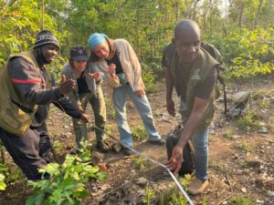
The end of March was spent preparing for the verification audit. Around thirty plots were initially selected at random. Of these, the auditors check half, generally based on the stratum. For example, three plots sown in 2021, four from 2022, three from 2023, and so on. To ensure the site visit programme can be completed within a few days, it is also important to check that each plot is accessible.
On the selected plots, our partners at South Pole insisted that the GUIDRE teams repeat the tree measurements taken in November, to be absolutely certain of avoiding any unpleasant surprises. The tree measurements taken in the presence of the auditors must correspond exactly to those taken before the audit. There is no room for error. Yet surprises cannot be ruled out: traces of past fires or livestock grazing, a baseline tree that has been ‘overlooked’ or ‘added’… several issues that will then need to be explained and justified to the auditors. And then there are the unforeseen complications of the journey: UNHAS has once again cancelled a domestic flight at the last minute, and we’ve had to organise the auditors’ journey by road from Conakry to Linko. Covering 800 km in 24 hours to keep to the audit schedule is quite a challenge!
Despite these minor issues, the audit went very well from 7 to 11 April, thanks to everyone’s good humour and the Guinean interpreter, who was far more competent than the previous one. After all, it is not just a matter of measuring trees: the auditors also want to interview beneficiaries in the villages to ensure that all the co-benefits we claim to generate are actually real.
We were even able to save time on the programme because the auditors decided to re-measure only a sample of trees per plot. But there was a slight problem: the new measurements taken during the audit often revealed a greater number of trees taller than 2 metres than the measurements taken in November, six months earlier. The reason was quite simple: the four days of exceptional rainfall in March (due to climate change…) had immediately caused young trees to grow above the 2-metre mark!
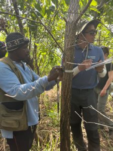
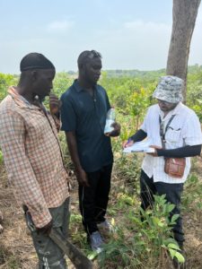
In the field, Pranam takes charge of measuring the trees, whilst Adak interviews the landowners with the help of the interpreter:
The audit concluded on a very positive note, as the Carbon Check auditors identified just one ‘finding’ relating to fieldwork: during future checks, we will need to mark the trees measured during our forest inventory, so that only those trees are re-measured during the audit (and not those that have grown as a result of the rain).
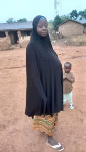
Mariame Condé has been a ‘seed family’ in the village of Kofilakoro since January 2022. She harvests the Carapa procera (Kobi) species. Let’s hear her describe her experiences in her mother tongue, Konianke, translated by Sékouba Condé, one of the supervisors at our partner organisation GUIDRE:
My name is Mariame Condé, a seed family. This project has changed my life. In 2022, I was pregnant and collected 20,000 seeds. The project paid me 1,000,000 GNF, which was a relief. At the time, my husband had gone to Sigiri, a mining area, to search for gold, and our harvest was almost gone. I used the money from Arborise to buy food and clothes for my son.
In 2023, I received 1,000,000 GNF and bought two sheep. I also got a large tarp that makes collecting seeds easier. After the seed harvest, I used the tarp to dry my rice and for my children to sleep on.
In 2024, I received another 1,000,000 GNF from Arborise and increased my sheep count. I’m happy with this project because it helps us and fights poverty. I now have 7 sheep, which are savings for my children.
Our seed harvest is done, but I profit from my sheep, and we women have formed a group (CGC SABOUGNOUMA DE KOFILAKORO). Each year, we produce lots of peppers, okra, and peanuts. It’s thanks to this mega Arborise-Guidre project that our lives have changed.
I’ve never seen a project like this that gives so much money to our husbands (land families) and us, while helping create forests that bring water to our streams. Mr. Condé, you know that from 2021–2023, the stream you once crossed dry now has water year-round.
I love this project because it keeps its promises. We’ve always received everything in the agreement—and more, like fencing, tarps, machetes, plows… always on time.
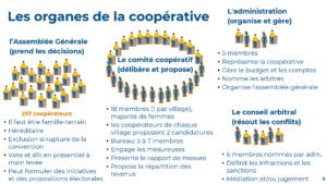
One of the Cooperative’s objectives, and the main role of the Cooperative Committee, is to develop a carbon revenue sharing formula. Indeed, it is certainly not up to arboRise to define how these revenues will be shared among the cooperative members. This choice must be made by those most directly concerned, based on local traditions and customs.
But what will these criteria be? And how should they be weighted? Should effort and merit be taken into account, or should revenues be distributed evenly? Can fate be invoked to justify certain disappointing results? Etc.
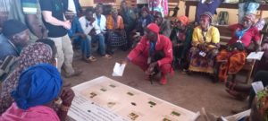
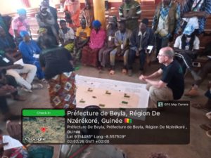
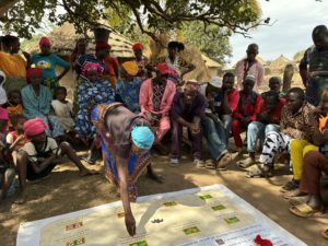
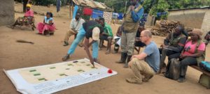
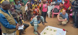
Rather than discussing these criteria in the abstract, we opted for serious games, which are more effective. In concrete terms, we used pre-printed tarpaulins showing several scenarios, such as this one, where the aim was to distribute income according to the hazards suffered by landowners:
Each member of the cooperative committee had 20 (symbolic) coins representing the project’s carbon revenues and was tasked with distributing them among the 10 situations presented on the tarpaulin, then commenting on their choice in front of their peers.
Over the course of the day, a consensus quickly emerged on the principles of carbon revenue distribution, for example:
Compliance with the cooperative’s rules by each member must be rewarded in proportion to the effort required to comply with each rule. For example, certain ‘costly’ rules (installing firebreaks around plots) must be better remunerated than simple rules (installing barrier tape to mark plots).
Of course, those who make a significant commitment to promoting tree growth on their land should be rewarded, but it is also necessary to give a little to those who are ‘undeserving’ because otherwise they may leave the project.
It is necessary to (very clearly) reward the result (the density and height of the trees on the land) and not the effort that was necessary to achieve this result.
External factors (soil infertility, fires, etc.) should not be considered inevitable: it is the responsibility of the land family if they have chosen unsuitable land or if their land has been affected by fires.
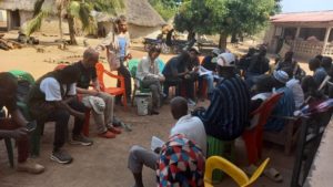
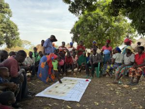
Over the following days, we repeated the same tarpaulin exercise in the 18 villages, visiting two villages per day, with all the field families in the village and in the presence of the two members of the village cooperative committee. The idea was to show the field families the complexity of the Cooperative Committee’s task, and it also allowed everyone to express aloud what they were all thinking: in the end, it will be those who achieve results who will receive the most carbon revenue. Another reassuring lesson is that there are no real differences between the villages: the distribution choices are fairly consistent.
At the very end of the tarpaulin exercise, we asked each village, ‘How much of your carbon income would you be willing to share freely with your village?’ Most participants indicated that they were willing to share about 10% of their carbon income with their community. With this, the villages will be able to develop their infrastructure (wells, market gardens, health posts, schools, etc.).
We also discussed opportunity costs with the families involved. By lending their land for reforestation, these farmers are potentially foregoing income from their crops. We therefore worked with them to examine the details of hillside rice cultivation in order to understand all aspects of it (yields, expenses, crop duration, fallow periods, etc.).
In total, 186 people from 18 villages, representing 72% of all the families involved, took part in this deliberation process. For arboRise, participatory reforestation is not just an empty phrase. It is essential that everyone has a say so that they can all take ownership of the project.
In our experience, one of the drivers of change in any organisation or social group is its leaders. Our process also aims to facilitate the emergence of new leaders, legitimised by transparent elections in their villages and then at sub-prefectural level within the Cooperative. Of course, current political leaders (sub-district chief, mayor of Linko, village chiefs) are involved in the process. They welcome the momentum generated by the project in the region. Indeed, we are convinced that it is the networking of leaders (old and new!) that will be decisive.
In December 2025, we founded the Samana Family Land Cooperative to properly manage the common good that is the new arboRise forests (see our report here), and on 1 February 2026, a new General Assembly was held to elect the cooperative’s governing bodies:
In preparation for the election of the 18 members of the Cooperative Committee, each village had previously elected two representatives, one man and one woman. At the general meeting, we simply used a hat in which we placed 10 ‘Woman’ tickets and 8 ‘Man’ tickets. Each village drew a slip at random, and that is how we ended up with a Cooperative Committee made up mostly of women, all of whom are well known in their villages and therefore visible at the sub-prefecture level.
—-
In this regard, some circles readily express sympathy for the plight of African women. For our part, we see tangible signs of their influence that contradict this image of weakness. For example, in a village in the sub-district, the women deposed the village chief who was reluctant to have the village join the project! Another example: a woman from the village of Booko heads the hunters’ guild for the entire sub-prefecture, an extremely powerful position that carries significant customary powers. A third indication is that the requirement for a majority of women on the cooperative committee has never been challenged or even debated. To conclude this digression, here is an inspiring read on the subject: L’autre langue des femmes (The Other Language of Women) by Léonora Miano.
—-
…We then moved on to electing the five members of the administration. The cooperative members from each village first chose their village’s candidate, then the entire room voted by a show of hands for each candidate, and the five with the most votes were elected. We are very pleased with the election of Mr Mamady Kourouma, from the village of Farawanidou, as Director of Administration, and that Ms Mariam Sidibé from Sokourala will represent women within the Cooperative’s Administration.
Each candidate first introduced themselves to the Assembly, then the five members of the administration were democratically elected.
The day after the General Meeting, we organised a training session for the five members of the administration and the 18 members of the Cooperative Committee and their deputies to prepare them for their roles and responsibilities.
For the Administration, it’s simple: they have to manage the budget and organise the next General Meeting (thus relieving our partner GUIDRE, which had been responsible for this until now).
For the Cooperative Committee, it is more tricky: they must appoint surveyors to visit and assess each plot of land and then, based on their report, develop a carbon revenue distribution key. Indeed, it is certainly not up to arboRise to define the criteria for distributing this revenue. This choice must be made by those most directly concerned, based on local traditions and customs.
But what criteria should be used to distribute carbon revenue? You can find out here.
In Samana, we also need to measure the pre-existing biomass (baseline) on a sample, as was done in Damaro in 2025. We should have taken these measurements in 2024, the year the plots were seeded. Measuring these trees two years too late means that their biomass will contain two years of growth and therefore two years of carbon that belongs to the project but that we will have to deduct (since, as we remember, the project cannot account for pre-existing carbon on the land prior to project activities).
Measuring pre-existing biomass requires several steps:
EcoAct calculates the sample size, performs stratification, and randomly identifies the sample plots and GPS coordinates of the measurement point on each plot.
We update the standard operating procedure and train GUIDRE
For each of the 40 plots, GUIDRE’s measurement teams must
find the plot in the given village
mark the perimeter of the 600 m² circular plot with barrier tape
identify all existing trees, measure their diameter at breast height and height, and identify the species of each tree
send the data via the Kobo-Collect form
The results show that stratification, based on satellite images, is validated by the reality on the ground. It can also be seen that the number of pre-existing trees per plot is reflected in the NDVI value during the dry season (NDVI measures vegetation health via satellite). NDVI is therefore a relatively robust indicator of pre-existing biomass.
On average, we will need to deduct 30 tonnes of biomass from existing trees from our subsequent measurements.
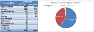
Our reforestation project removes CO2 from the atmosphere, but what is the carbon footprint of arboRise’s activities? How much CO2 do the project’s activities emit into the atmosphere?
This carbon footprint is based on the Bilan Carbone™ methodology and lists all GHG emissions from arboRise and GUIDRE activities in Switzerland and Guinea for the two regions (Linko-Damaro-Konsankoro and Samana-Diassodou-Sokourala-Koumandou) during the 30-year and 20-year certification periods, respectively.
Summary of results:
This carbon footprint of 1,100 t CO2e will enable the absorption of 2,400,000 t CO2e thanks to the reforestation activities carried out by arboRise and GUIDRE in two regions (Linko-Damaro-Konsankoro and Samana-Diassodou-Sokourala-Koumandou) over a period of 20 and 30 years respectively. The project’s emissions therefore represent only 0.5% of the CO2 that the project will remove from the atmosphere.
Comments and potential for improvement:
The travel of GUIDRE teams in the field is, of course, the main source of CO2 emissions. In the long term, the use of electric vehicles will need to be considered and tested.
Air travel (project leader, auditors, partners, business visitors) accounts for 18% of the total (196 t CO2e). If all non-employees (auditors, partners, business visitors) were represented by only one person instead of two, this would save 72 t CO2e. This requires a change in standards and practices. When the Transguinéen railway is available, we will be able to replace internal flights with train travel.
Half of the input footprint is made up of meals for GUIDRE teams in the field, which are difficult to reduce unless they become vegetarian (meat footprint: 123 t CO2e). Other inputs with a significant footprint are fencing and tarpaulins for seed families.
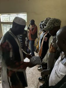
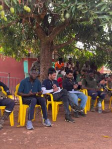
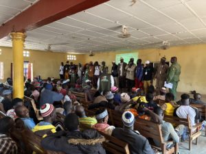
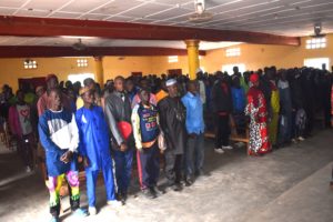
A historic day in the sub-prefecture of Samana on 13 December 2025: Samana’s first cooperative, bringing together the 248 farming families of Samana, was founded in the presence of local authorities.
The 248 cooperative members were invited to gather at the Youth Centre in the commune’s capital. Such an event is exceptional in the region: most of the participants were very surprised to receive two good meals during the day as well as a daily allowance.
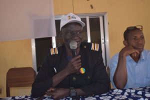
The Samana authorities were invited and the sub-prefect of Samana gave a very inspiring speech, which we recorded and broadcast on local radio. The main theme of the day was to explain ‘why create this cooperative’ (to better manage the reforested plots that are the common property of all families) and to prepare for the elections of the cooperative’s governing bodies at the next general meeting in March 2026.
The Samana Cooperative is already the second, following the creation of the Linko Cooperative in 2023.
201 participants gathered at the Samana Youth Centre. The building was just large enough to accommodate the assembly.