Foundation of the arboRise Cooperative

assemblée constitutive

Bringing together all the families in Linko’s arboRise family cooperative has several objectives:

  1. foster mutual trust between families
  2. provide a forum for exchanging best practice
  3. enable the families concerned to decide for themselves, without any involvement from arboRise, how the income from the carbon credits is to be distributed.

This deserves some explanation.

At the outset, some people thought that the project would somehow create competition between family plots and distribute more money to the families on whose plots the trees grow best. A form of rivalry between families and villages was then perceptible, with each criticising the others, convinced that they belonged to those who were doing well (an attitude not so different from what we see in Europe, where everyone considers themselves to be very virtuous in terms of CO2 emissions, compared with the others).

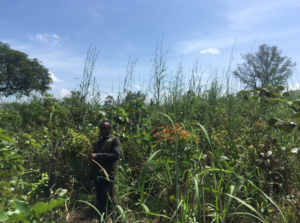
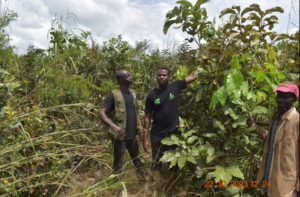
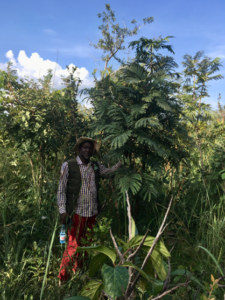
The auditor of our carbon certification standard will not be measuring the biomass of each of the 6,000 hectares that we will have reforested in 9 years’ time. He or she will measure the carbon on a representative sample. And the project’s carbon income will be calculated on the basis of this sample.

If, by chance, there are only lots with a high density of trees in the sample, everyone will be happy: the sample average will be high and all families – not just the families whose lots have been measured – will be able to receive high incomes. But if the sample includes plots whose trees have been cut down, everyone will suffer.

The average biomass measured in the sample is therefore a common good shared by all the families. All the families have an interest in helping each other to ensure that all the plots of land are in good health and that this common good bears fruit. This is why the cooperative was created: to provide a structure that facilitates this collaboration for the next 27 years. In this way, the arboRise project strengthens community solidarity (see our ethical charter). The hand that calls for help is transformed into a chain of people helping each other:

arboRisese donner la main

The statutes of the cooperative initiated by arboRise draw heavily on the research of Elinor Ostrom, winner of the Nobel Prize in Economics for her work on the good governance of common goods. In particular, they aim to guarantee gender parity within the Cooperative Committee, the body of the Cooperative that will propose the income distribution key to the members. Don’t hesitate to ask us for more details about the profit-sharing mechanism, if you’re interested.

Founding a co-operative means bringing together all the co-operators, 265 people in our case. Plus the representatives of the Community Management Committees in each village and other representatives of the authorities… in the end, there were more than 300 of us.
300 guests, for whom we had to provide accommodation, food, a meeting place, etc. etc. And all this in the middle of the bush.

Assemblée Générale de la Coopérative

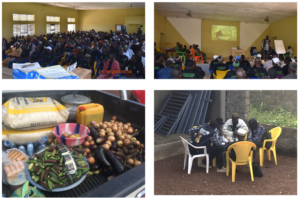
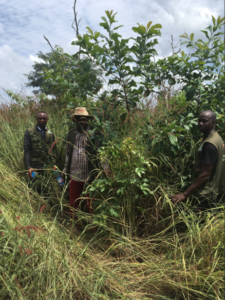
Once again, our partner GUIDRE performed this task brilliantly. The families from the most remote villages arrived the previous evening and were accommodated by families in Linko. The rural radio station was able to broadcast a round table discussion with some of the beneficiaries (photo bottom right). And everything went smoothly on the day of the inaugural meeting. It must be said that we had anticipated things well, having prepared the event with the Community Management Committees in May. A big THANK YOU to our partner GUIDRE for its professionalism and commitment.

The next step is to support the process of electing the Cooperative’s governing bodies at the next Annual General Meeting.

Conservation perimeter

cours d'eau

To increase the environmental impact of a carbon project, the Gold Standard requires each project to define a conservation perimeter equivalent to 10% of the project area. This area must be protected from any exploitation activity and is not eligible to receive income from carbon credits. It is truly a perimeter dedicated to biodiversity.

This is easier said than done, because in the case of arboRise it means finding more than 180 hectares for each cycle of 1,500 hectares. Fortunately, the communities we work with are very interested in preserving their environment. They know exactly which areas of the village are important. These include

  • the spring heads (where water gushes out of the ground), which are very fragile and vital for providing the water needed in the village: for cooking, for market gardening, for cleaning, etc.
  • sacred forests, which often surround the villages and into which it is forbidden to penetrate under threat of very serious trouble. These remnants of primary forest are real reservoirs of biodiversity, providing food for animals and seeds for the surrounding area. These forests are also under threat as modernity replaces ancestral traditions.
  • groves where the ritual initiations of young men and women take place.
  • wetlands: streams, marshes, low-lying areas, etc. that are often home to wildlife.

forêt sacrées sacred forest

These sensitive and precious areas are currently only protected by tradition and its guardians. Under the Forestry Code, the Guinean government provides support for communities wishing to protect certain areas. It is possible to put these areas under protection, which legally protects them for 99 years. In practical terms, this means that these areas are now also under the protection of the State, represented by the Water and Forestry Department of the Ministry of the Environment and Sustainable Development. Penalties are provided for anyone guilty of damaging these protected areas.

Each village deliberated to identify the area or areas to be protected, usually sacred forests. These areas were then geo-referenced by our partner GUIDRE, whose director is regional manager of the ICCA consortium. Each village made an official request to the Water and Forestry Department for the areas to be set aside, and finally the Prefect of Kérouané signed the 25 certificates for the areas to be set aside, covering a total area of almost 200 hectares, thus protecting them from anthropic pressure.

Map of conservation areas:                                                                              A prefectoral certificate:

zones conservées conservation zonesAttestation du préfet

Trees seen from space

2022-035

For the past year, we have been measuring NDVI, i.e. biomass on reforested land, using images from the European Union’s Sentinel II satellite. To validate this tool, we need to ensure that the satellite measurement values match the reality observed in the field.

That’s what we wanted to find out during our latest supervisory visit. We visited 15 sites to be reforested in 2021 and 2022, some of the most extreme in terms of biomass measured by satellite: basically the best and worst sites. Of this non-representative sample, the observations on 11 plots correspond to the satellite values (70%). For the remaining 4 sites, the satellite values are too negative in 3 out of 4 cases.

Satellite measurements could therefore be used to help our beneficiaries by telling them where their land is situated, in terms of biomass, in relation to all the other land. This will enable them to take informed action, for example by enriching their plots with new seeds or wildings if the biomass is below average.

Here are a few examples of good matches:

Field 2021-034, near Oussoudougou. The good NDVI value for February 2023 in the dry season (0.211) reflects the reality on the ground:

2021-034

Field  2021-015, near Diaragberela. The poor NDVI value for February 2023 in the dry season (0.156) reflects reality in the field:

2021-015

Field  2021-016, near Diaragberela. The relatively good NDVI value for February 2023 in the dry season (0.203) reflects reality in the field:

2021-016

Field  2021-056, near Konko. The poor NDVI value for February 2023 in the dry season (0.143) reflects the reality on the ground:

2021-056

Field  2021-044, near Fansan. The poor NDVI value for February 2023 in the dry season (0.183) reflects reality on the ground:

2021-044

Field  2021-031, near Talinko. The poor NDVI value for February 2023 in the dry season (0.174) reflects the reality on the ground:

2021-031

Field 2022-035, near Talinko. The good NDVI value for February 2023 in the dry season (0.262) reflects the reality on the ground:

2022-035


And here are the 4 cases of non-correlation:

Field 2021-004, near Linko. The NDVI value for February 2023 in the dry season (0.152) is poor and does not fully reflect the reality on the ground, which is better, perhaps due to the effect of the rainy season:

2021-004

Field 2021-009, near Linko. The NDVI value for February 2023 in the dry season (0.163) is poor and does not at all reflect the reality on the ground, which is much better:

2021-009

Field 2022-150, near Linko. Field observations do not correspond with the correct NDVI value for February 2023 in the dry season (0.226):

2022-150

Field 2022-191, near Diaragberela. Observations in the bushy terrain do not correspond to the incorrect NDVI value (0.182):

2022-191