
Predicting land clearing is important for our project. That is why, once again this year, we have collaborated with EPFL as part of a Design Project.
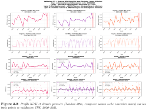
Feryel El Phil and Camille Dupré Tabti first demonstrated that the first derivative of NDVI values is a good method for identifying when land is being cleared.
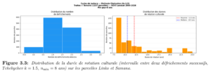
This enables them to calculate the crop rotation cycle for each plot of land. As can be seen below, this varies considerably: some plots have a rotation cycle of 7 years (roughly 2 years of cultivation, 5 years of fallow), whilst others can be as long as 25 years:
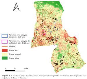
Building on these findings, they then produced a map showing the probability of land clearing in Linko and Samana and concluded that the risk of our plots being cleared increases if the land is easily accessible to farmers (close to the village) and if it is naturally fertile. We can therefore predict which land-owning families would be most likely to reconsider their participation in the project if they are not satisfied with the carbon payments they receive.
The full analysis report is available here: DP_Leakage_final_report
