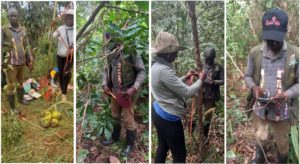
As we have seen, manually measuring trees for verification purposes is very time-consuming. Furthermore, biomass is estimated using an allometric equation that only takes into account diameter and height.
About allometric equations:
-
-
- Chave et al, 2005: Tree allometry and improved estimation of carbon stocks and balance in tropical forests
- Djomo et al, 2010 : Allometric equations for biomass estimations in Cameroon and pan moist tropical equations including biomass data from Africa
- Chave et al, 2014 : Improved allometric models to estimate the aboveground biomass of tropical trees
-
What about biomass in branches? Is it sufficiently taken into account by equations, which are often not based on forest measurements, regardless of species?
Other dendrometric measurement methods exist, which generally use scanners (TLS: terrestrial laser scanner).
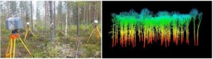
Numerous studies show that the accuracy of the measurement and the time required are similar to manual measurements, but this equipment is very expensive (CHF 60,000).
Since 2021, most iPhones and iPads have included a lidar (laser) scanner, and specific applications for tree measurement have appeared in the App Store. The cost is much lower than TLS equipment, and the mobility allows for the resolution of occlusion problems faced by fixed TLS. We wanted to test this approach.
There is already a wealth of scientific literature on the subject:
- Arne VAN WOLPUTTE, 2024: Mobile LiDAR technology for forest biomass inventories and carbon certification monitoring
- Noah A Howie, Andrea De Stefano, 2024: Measuring Tree Diameter Using LiDAR Equipped iPad: An Evaluation of ForestScanner and Arboreal Forest Applications
- Christoph Gollob et al, 2021 : Measurement of Forest Inventory Parameters with Apple iPad Pro and Integrated LiDAR Technology
- Rogério Bobrowski et al, 2023: Best practices to use the iPad Pro LiDAR for some procedures of data acquisition in the urban forest
- Shinichi Tatsumi, Keiji Yamaguchi, Naoyuki Furuya, 2022: ForestScanner: A mobile application for measuring and mapping trees with LiDAR-equipped iPhone and iPad
- Nozomi Oikawa et al, 2025: Utilising LiDAR-equipped iPhone in forestry: Constructing 3D models and measuring tree sizes in a planting site
Based on these studies, we selected two applications to test. Unfortunately, ForestScanner and Arboreal Forest only measure diameter (but they do so very well) and create a digital terrain model. We would have liked to see real 3D images of each tree.
We then tested two 3D modelling applications (3D Scanner app and Polycam), but the results were inconclusive: scanning a tree from all sides takes several minutes and it is still impossible to scan the tree from above, so the 3D image of the branches and crown is incomplete. Furthermore, when the undergrowth is dense, with lots of foliage (which moves in the wind), the scanner has difficulty working properly.
Conclusion: manual measurements are still more advantageous in terms of speed, cost and accuracy. But thank you to all the application developers who provide very useful tools for measuring monocultures.